
Cameroon has over 400 km coastal area, with numerous and special genres of fauna and flora species. Unfortunately, indiscriminate anthropogenic intrusions are posing as a serious threat to these coastal areas, requiring urgent intervention by the Government/decision makers in the Country. In making decisions on the effective management of the country’s coastal areas, decision-makers must be informed about geographical, biogeographical, environmental and ecological aspects. This is where geospatial science comes in!
Geographical Information Systems and Remote Sensing techniques are key to ensuring a better understanding of coastal areas in Cameroon. With these technologies, policy makers and environmental actors have a better picture of the evolution of coastal zones over the years, and the actual demarcation between land water, both in the rainy and dry seasons. This can be made possible via high resolution satellite images. Meanwhile, Radar and Lidar technology, can then assist in mapping out the extension of land part in the ocean (which is called continental slope). By doing that, the coastal relief can be clearly mapped out.
One other great challenge faced by the country’s coastal areas is erosion. Even, at this level, GIS / Remote Sensing has a key role in ameliorating this plight. With aerial photographs, evolution of erosion can be captured and monitored for effective management mechanisms to be put in place. The monitoring of coastal systems dynamism is a combination of aerosaptial data and ground data. Both types of data are inputted in a particular model designed in GIS environments. The dynamism of coastal lands can be mapped out at two levels: the disappearance of biological species and the regression of the sea.
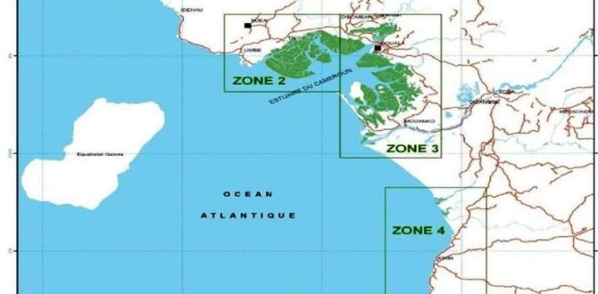
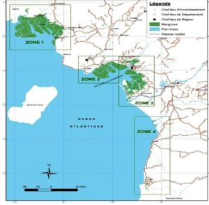
Inventory of species and ecosystems depletion in coastal areas by different researchers can equally be facilitated using remote techniques. With GPS ground thruthing, mangrove, which is the main vegetation directly in contact with water, can be mapped using satellite images. The various species of the vegetation is detected and land cover changes of such species are being mapped using remote sensing techniques. Apart from mangrove, the coral reef can also be mapped out for conservation.
Also, geospatial technologies can add great value to fishing activities in coastal areas in Cameroon. With remote sensing / GIS techniques, potential fishing areas can be mapped. This is done by observing the oceanographic features such as thermal boundaries, fronts, eddies, rings, gyres, meanders and up welling regions. It therefore becomes very important that geospatial technology be inculcated in coastal conservation initiatives for effective management of coastal areas in the country.
Eugene Dongmo Alontsi
GIS Specialist


Your web site has outstanding material. I bookmarked the site