
Eugene DONGMO ALONTSI, GIS Specialist
Studying and tracking the movement of animals and their way of living is more and more becoming very important. This is especially crucial given that the movement of plant and animal species across the globe has no respect for territorial frontier. This has thus, made the detailed mapping and analysis of geographic features, species distribution and natural resources a key need in the field of conservation.
The multidisciplinary study of conservation biology was developed to build a bridge between pure ecology and the practical issues of species and habitat conservation. The development of information systems and methodologies to solve complex problems in conservation has however, remained a great challenge.
The use of Geographic Information Systems today, is proving to be a great way out as it allows researchers in biodiversity conservation to easily collaborate in different aspects like designing and modelling of wildlife corridors, biodiversity conservation, and predicting changes in land use patterns.
GIS’s Role in Designing and Modelling Wildlife Corridors
Knowing that animals do not recognise local, national and international boundaries in their movements, it is important to map out their movements. This exercise requires many sources of information such as species data, land use land cover, soils, topography, hydrograph etc. The final result is produced in form of various highways that animal are using to move from one habitat to another. This information help conservation experts and stakeholders to know how to deviate corridor(s) to protect human activities without necessarily destroying wildlife habitats. It equally gives a much better understanding of the specificities of different wildlife habitats.
GIS’ Role in Biodiversity Conservation
Conserving species is one of the main ways to mitigate climate change. Be it species conservation or climate change, emphasis is always laid on data availability and accuracy. To achieve such objectives, GIS contributes a lot in creating spatial information. It gives information on species distribution within specific geographic areas. GIS also provides information on available protected areas and the areas which are free to be occupied. GIS data also assist conservation experts in identifying more suitable areas for conservation. With the evolution of technology and techniques, GIS makes it easy to monitor wildlife species and to map out their movement for conservation.
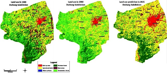
GIS and Change Prediction
As far as the conservation of species is concerned, GIS has been used for prediction of the future events. Changes in land use patterns is one of the greatest challenge for conservation today. In that light, GIS combines data coming from diverse sources such as multi-dates satellite imagery, human activities and other topographic data. This kind of information are modelled in using various methodologies and techniques. At the end of the process, the prediction of land degradation or changes is mapped within a specific period of time. Conservation experts use such information to better plan reforestation, protected areas creation, other conservation programmes.


Do you have any type of suggestions for creating short
articles? That’s where I always battle as well as I just end up gazing vacant screen for very long time.